About Amateur Radio Grid Square Tool
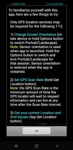
For a tasklist to familiarize yourself with this app, Hold the [ Help ] button or visit https://kg9e.net/GridSquareGuide.htm No ads, nags, or in-app purchases. This QTH Locator Grid Square calculato
For a tasklist to familiarize yourself with this app,
Hold the [ Help ] button
or visit
https://kg9e.net/GridSquareGuide.htm
No ads, nags, or in-app purchases.
This QTH Locator Grid Square calculator tool converts Latitude and Longitude geographical coordinates into Maidenhead Grid Square up to 5 pairs of resolution. This app assumes that by default your device reports Latitude and Longitude in Decimal Degrees and Altitude in meters.
To convert among Decimal Degrees (DD), Degrees Decimal Minutes (D:DM) and Degrees Minutes Seconds (D:M:S), tap the Latitude or Longitude value field. Tap on the Altitude field to convert between Meters and Feet.
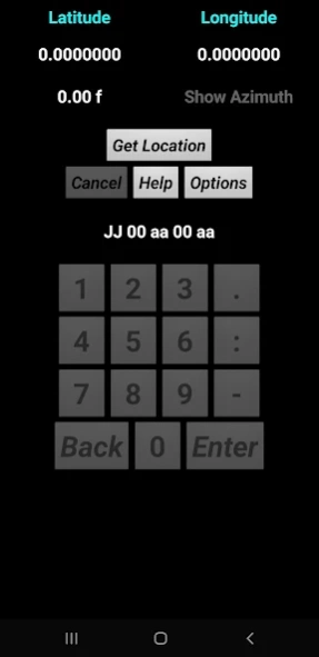
You may use the Location Sensor (if Location Services are enabled and set to GPS satellites) in your Android device to obtain your geographical location and calculate your current Grid Square, or you may enter a custom Latitude and Longitude via the numerical keypad to calculate a custom Grid Square.
To enter custom coordinates, tap and hold the Latitude and Longitude value fields and the Custom Coordinates numerical keypad will be enabled. You may enter coordinates in DD, D:DM or D:M:S format, depending on the current display.
Alternatively, if you have an Internet connection, you may use the Show Map option to display a map of your surroundings. Tap and hold on a map location to enter those coordinates as a custom Longitude and Latitude. Please note: the map shown is NOT a Grid Square map, but rather it is another way to enter a custom geographical coordinate for a custom Grid Square calculation.
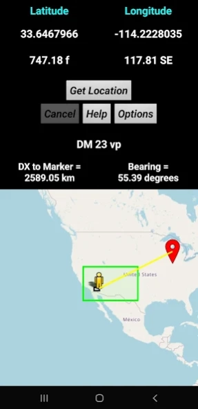
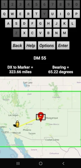
Using the Show Marker option, you may calculate the distance and bearing from your location to another by tapping on a desired location on the map or by dragging the Marker.
This app does not contain map data by itself. All map information is provided via the internet by OpenStreetView or the US Geological Survey map servers and performance is affected by your internet connection, map server availability, and the resource usage on your device. Furthermore, Zoom levels and details may be limited by the area in which you are interested or by the map type. Note that it may be possible to work offline with temporarily cached map data but results, if any, will be limited.
Additionally, with an internet connection or cached data, you may enter a custom 2, 4, 6, 8 or 10 character QTH locator value to show the Field (green), Grid Square (black) and SubGrid (dark blue) Extended Square (cyan), and Super Extended Square (red) location on a map. Tap and hold the Grid Square value field to enable the alphanumeric Custom Grid Square Keyboard arrangement and map.
If your device has an Orientation Sensor, then Azimuth readings will be displayed in decimal format and can be used as a compass. Tap on the Azimuth reading to show/hide.
This grid square calculator app will work in either portrait or landscape mode by rotating the device. Hold the Options button to override Sensor orientation and manually set portrait or landscape. Restarting the app returns to Sensor orientation.
Optionally, you can choose to have your device sound and/or vibrate if the custom coordinate input is invalid or out of range, and with the Speech On option the Grid Square will be read to you in phonetics each time it changes.
You may also choose to enable DTMF tones on the keypad. The Decimal key doubles as DTMF *, and the Minus key doubles as DTMF #.
This app is intended as an amateur ham radio Grid Square calculator tool and QTH locator for VHF/UHF radio contesting and QSO parties. Preppers and Survivalists may have an interest as well. Despite its features, it is not intended to be a personal navigator, geocaching tool, trip planner, hike mapper, pet finder, etc...
Previous Versions
Here you can find the changelog of Amateur Radio Grid Square Tool since it was posted on our website on 2020-12-28 20:55:08.
The latest version is 1.0.18 and it was updated on 2024-04-22 18:52:40. See below the changes in each version.
Amateur Radio Grid Square Tool version 1.0.18
Updated At: 2023-09-27
Changes: TargetSDK=33, per Google requirements.
Amateur Radio Grid Square Tool version 1.0.16
Updated At: 2023-01-24
Changes: Now calculates up to 5 pairs of resolution.
Additional options.
Amateur Radio Grid Square Tool version 1.0.12
Updated At: 2021-06-09
Changes: Replaced app icon with adaptive icon.
Amateur Radio Grid Square Tool version 1.0.11
Updated At: 2021-04-23
Changes: Orientation set to Sensor, so you can change from portrait to landscape.
Hold the Options button to override Sensor and manually set portrait or landscape mode. Restarting the app returns to Sensor orientation.
Amateur Radio Grid Square Tool version 1.0.8
Updated At: 2020-03-22
Changes: Distance and bearing to marker automatically calculated when using maps and custom grid square.
Disclaimer
Official Google Play Link
We do not host Amateur Radio Grid Square Tool on our servers. We did not scan it for viruses, adware, spyware or other type of malware. This app is hosted by Google and passed their terms and conditions to be listed there. We recommend caution when installing it.
The Google Play link for Amateur Radio Grid Square Tool is provided to you by apps112.com without any warranties, representations or guarantees of any kind, so access it at your own risk.
If you have questions regarding this particular app contact the publisher directly. For questions about the functionalities of apps112.com contact us.